The Southern Ocean

Observing System

Facilitating and Enhancing Global Southern Ocean Observations

Recent highlights from the New Zealand Antarctic Programme

Image

May 2020

From the world’s largest ice shelf, to the depths of Terra Nova Bay and the sea ice in McMurdo Sound, Antarctica New Zealand is the government agency responsible for carrying out New Zealand's activities in Antarctica. New Zealand’s Antarctic research programme has a strong focus on how the continent and its ecosystems will be impacted by climate change, and how those changes will influence the rest of the planet. During the 2019/2020 summer field season, ocean-related research supported by Antarctica New Zealand spanned a variety of disciplines and locations.  
 
Image
Close to Scott Base in McMurdo Sound, scientists studied the interannual variability of sea ice. As an important regulator in global climate, researchers are interested in what the sea ice is doing now, and what it might do in the future. In spring 2019, instruments were deployed in the sea ice to record characteristics such as snow depth and the vertical temperature gradient. Building on 20 years of data collection, this research aims to improve understanding of how ocean processes occurring beneath ice shelves influence sea ice formation.

As well as the physical elements of sea ice, biological components were studied too. A team of researchers investigated how sea ice algae might respond to changing environmental conditions. Using an underwater remotely operated vehicle, the in-situ response of algae to environmental stressors was measured. The team also implemented an under-ice hyperspectral camera run on skis to record images of sea ice microbes to determine abundance and community composition.
 
At the opposite end of the food chain, scientists studied ocean predators, including Weddell seals, Emperor penguins, Adélie penguins, and killer whales. Research focused on where the animals travel, how deep they dive, and what they are eating. These data will help with understanding how effective the recently established Ross Sea region Marine Protected Area (MPA) is.
 
There were also a number of long-term monitoring surveys carried out during the season, including the annual aerial census of Adélie penguins on Ross Island. High resolution photographs were taken from a helicopter and later analysed to determine the total number of breeding pairs. These aerial surveys began in the 1980s, and the long-term record of Adélie penguin abundance and distribution provides an important baseline for research and monitoring associated with the Ross Sea region MPA.

Later in the season, the annual Antarctic toothfish survey was carried out from aboard the FV San Aotea II, contributing to a record that began in 2012. The results of the survey help with sustainable management of the toothfish fishery as well as informing how effective the Ross Sea region MPA is in terms of achieving its conservation objectives.

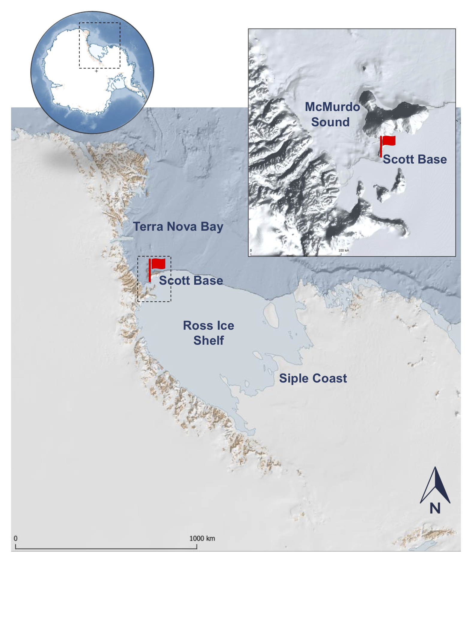
Over 1000 kilometres from Scott Base, a team of scientists studying the Ross Ice Shelf were deployed at Siple Coast. This region is home to the grounding line of the West Antarctic Ice Sheet, where the ice starts to lift off the land and begins to float. Using a hot water drill, a 534 metre deep hole was drilled through this region of the ice shelf for the first time, reaching the wedge-shaped ocean cavity below. A long-term oceanographic mooring was installed to investigate physical properties of the ocean, and marine sediment cores were retrieved to help inform multidisciplinary studies of the stability of the Ross Ice Shelf during past warm periods. In addition, a NASA-funded under-ice robot (Icefin) was deployed through the drill hole to remotely explore the ocean cavity.  A better understanding of ocean processes under the ice shelf will feed into models of ice dynamics and sea level rise projections.

 
Further north in Terra Nova Bay, a multinational team of New Zealand, Korean and Italian researchers continued a long-term study of sea floor communities. Using remote video cameras and photogrammetric techniques, the scientists gathered data to understand how fast different components of the community will respond to climate change.  Also in Terra Nova Bay, onboard the Korean RV Araon a team worked to recover, download, and then redeploy oceanographic instruments attached to moorings. These instruments record temperature and salinity at various depths, revealing insights into processes associated with the Terra Nova Bay polynya. The polynya is an important area for the production of sea ice, as well as the cold, dense, salty bottom water that plays a key role in global ocean circulation.

Antarctica New Zealand is proud to be supporting world-leading science that is fundamental to improving our understanding of the impact of environmental change in, on, and around Antarctica and the Southern Ocean, and the impacts of that change on rest of the world.
Image

Data Efforts

Image
Data sharing is at the heart of SOOS. Our aim is to support the development of systems that maximise the discoverability, access and impact of Southern Ocean observations, no matter who collected them, or when, or why.
Image
Image
Explore and download curated and standardised Southern Ocean observational data on an interactive map.
Image
Image
Search the SOOS portal at NASA's Common Metadata Directory (CMR) for worldwide Southern Ocean data.
Image
Image
Find and share upcoming expeditions to the Southern Ocean with international colleagues.
Image
Image
Explore Regional Working Groups that coordinate and implemente the observing system in each region.

Field Coordination

Image
SOOS brings together existing communities and observational efforts to enhance the coordinated collection of observations, through the development of coordination networks and tools. These facilitate collaborative logistics, sharing of resources, alignment of observational priorities, and supporting community effort towards achieving the SOOS mission.

Enhancing Capabilities

Image
SOOS enhances our ability to observe the Southern Ocean integrated, multidisciplinary and sustained way, through support of community-driven working groups and task teaks. These efforts focus on development and implementation of technologies, building networks, improvement of observational design, and development of associated methods.
Image
Image
Explore Capability Working Groups (CWGs), developing and enhancing important Southern Ocean observational capabilities.
Image
Image
Find Task Teams producing specific products, organising events, or solving a particular observing problem.


Latest News & Events

Image

Enhancing observations of the Southern Ocean

Image
SOOS is an international initiative of the Scientific Committee on Antarctic Research (SCAR) and the Scientific Committee on Oceanic Research (SCOR).  SOOS' mission is facilitating the collection and delivery of essential physical, chemical and biological oceanographic observations from the Southern Ocean, to ensure all stakeolders have access to the data required to address key societal issues, such as sea-level rise, heat, freshwater and nutrient transport, and ecosystem responses to changes in the system.
Image
The SOOS 5-year Implementation Plan defines the actions of the SOOS community for the period 2021-2025.
Image
The Southern Ocean community has identified 5 scientific challenges that are used to focus our observational priorities.
Image
SOOS has a simple governance structure, with close connections to external scientific and coordination bodies.
Image
The International Project Office (IPO) is the central hub of the SOOS effort, click above for details on how to contact the IPO.

Sponsors

Image

Stay up to date. Subscribe to our newsletter